The US Forest Service publishes a variety of map products to help you plan your next adventure or enjoy your next visit!
Topographic Maps
FSTopo is the Forest Service series of large scale topographic maps. FSTopo maps are 7.5 minute, 1:24,000-scale over the conterminous United States, and 15 minute X 20-22.5 minute, 1:63,360-scale over Alaska. These maps are available in several formats:
GeoTiffs are derived from the PDF product and can be used in the GIS are available here.
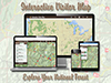
Discover recreation opportunities on your National Forest using the new
web-based and mobile friendly Interactive Visitor Map!
“A Guide To Your National Forests and Grasslands” (PDF, 1.41MB) is a free brochure
showing locations of national forests and grasslands along with contact information.
A large map of National Forests and Grasslands is also available.
View a Locator Map of our nation's national forests and Grasslands.
The markers and links on the map will take you to local forest/grassland web sites
where additional information can be obtained.
Forest Visitor Maps for each national forest and grassland provide forest-wide information on attractions,
facilities, services, and opportunities.
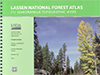
National Forest Atlas
National Forest Atlases are full color atlases,
containing 8.5 x 11” topographic quadrangle maps at 1 inch to the mile scale
and are available for many of the forests in California.
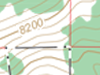
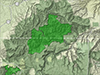
Wilderness Maps
Wilderness Maps are topographic maps, which show natural features,
such as mountains, valleys, plains, lakes, rivers, and vegetation.
This is done through contour lines depicting elevation gain or loss.
This way you will have a sense about how steep that mountain is that you'll be climbing this weekend!
Each map covers all or part of one wilderness area and the scale is generally 1 inch per mile (1:63,360).

 FSTopo is the Forest Service series of large scale topographic maps. FSTopo maps are 7.5 minute, 1:24,000-scale over the conterminous United States, and 15 minute X 20-22.5 minute, 1:63,360-scale over Alaska. These maps are available in several formats:
 Discover recreation opportunities on your National Forest using the new
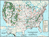 “
“ View a
 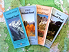 Forest Visitor Maps for each national forest and grassland provide forest-wide information on attractions,
facilities, services, and opportunities.
Forest Visitor Maps for each national forest and grassland provide forest-wide information on attractions,
facilities, services, and opportunities.
 National Forest Atlases are full color atlases,
containing 8.5 x 11” topographic quadrangle maps at 1 inch to the mile scale
and are available for many of the forests in California.
National Forest Atlases are full color atlases,
containing 8.5 x 11” topographic quadrangle maps at 1 inch to the mile scale
and are available for many of the forests in California.
 Wilderness Maps are topographic maps, which show natural features,
such as mountains, valleys, plains, lakes, rivers, and vegetation.
This is done through contour lines depicting elevation gain or loss.
This way you will have a sense about how steep that mountain is that you'll be climbing this weekend!
Each map covers all or part of one wilderness area and the scale is generally 1 inch per mile (1:63,360).
Wilderness Maps are topographic maps, which show natural features,
such as mountains, valleys, plains, lakes, rivers, and vegetation.
This is done through contour lines depicting elevation gain or loss.
This way you will have a sense about how steep that mountain is that you'll be climbing this weekend!
Each map covers all or part of one wilderness area and the scale is generally 1 inch per mile (1:63,360).
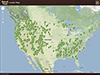
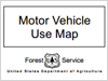 Motor Vehicle Use Maps have been prepared and issued to identify those roads, trails,
and areas designated for motor vehicle use.
Motor Vehicle Use Maps have been prepared and issued to identify those roads, trails,
and areas designated for motor vehicle use.