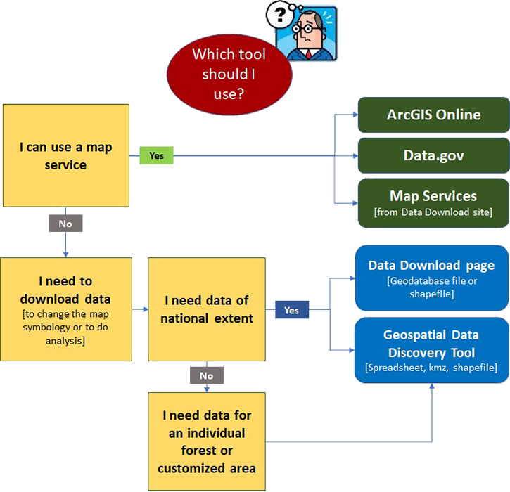
Use the following flowchart to find the data that best meets your needs. And be sure to scroll down the page to read through our frequently asked questions.
Which tool should I use?
Frequently Asked Questions
Q: How do I see whether certain data layers are available for a specific forest?
A: Some data is published on a forest by forest basis. The instructions in this PDF document will tell you how to determine whether certain data layers are available for a specific forest.
Q: Where can I find the new Forest Service National Monument boundary data?
A: The new national monument boundary data is now available to the public. Here is how you can get the information:
Q: Why would I download data versus using a map service?
A: You can use a data download to do analysis, such as combining with other layers, calculating areas or length, or to change the map symbology.
Q: What is a map service?
A: A web service that gives various clients access to the map and its underlying data over the network.
Clients communicate with the service via various protocols: REST, SOAP, KML, OGC WMS, etc. So you can take the map service and use it in virtually all ESRI produced clients. You can also use Google Earth and Google Map to display an ESRI map service. You can also use the service in a client application that understands the OGC WMS standard.
The map service allows you to get a map image with a predefined symbology, labeling, scale dependency, etc. You can find and identify information in the data exposed in the map service.
You can also query data layers in the map service to get back spatial and non-spatial information. Using the ESRI Javascript API and the map service's REST API a web developer can display the map service using a different symbology than what was defined in the map document.
Q: Some files are extremely large and take too long to download. What should I do?
A: You have a few options:
if you need a data download file, you might try downloading at a different time of day when there is less traffic on the server;