Infrastructure Notice: The Forest Service is undergoing significant infrastructure upgrades that will occur from late this week (starting July 24th) into the beginning of next week. Expect periodic outages during this time. Thank you for your patience as we continue to navigate toward new infrastructure!
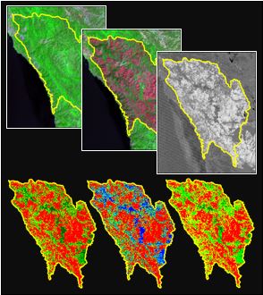
The Rapid Assessment of Vegetation Condition after Wildfire (RAVG) program assesses post-fire vegetation condition for large wildfires on forested National Forest System (NFS) lands. RAVG data are produced by the Forest Service Geospatial Technology and Applications Center (GTAC) by way of a multispectral change detection process. Standard products are calculated using regression equations that relate derivatives of Landsat or other similar imagery to three estimates of burn severity: percent change in basal area (BA), percent change in canopy cover (CC), and a standardized composite burn index (CBI).
Standard thematic products include 7-class percent change in basal area (BA-7), 5-class percent change in canopy cover (CC-5), and 4-class CBI (CBI-4). National mosaics of each thematic product are prepared annually.
RAVG data are produced to assist in post-fire vegetation management planning. They are intended to enhance decision-making capabilities and reduce planning and implementation costs associated with post-fire vegetation management. RAVG analysis provides a first approximation of areas that may require reforestation treatments after a fire. This initial approximation may be followed by site-specific diagnosis and development of a silvicultural prescription to more precisely identify reforestation needs.
The mosaics available at this website comprise the thematic products from published data for 2012 and beyond. Datasets for earlier years (namely, 2007 through 2011) may be added in the future.
The data are also available as map services via the Forest Service Raster Data Warehouse (https://apps.fs.usda.gov/arcx/rest/services/RDW_Wildfire).
The associated burned area perimeters are available via the Enterprise Data Warehouse (EDW, see https://apps.fs.usda.gov/arcx/rest/services/EDW).
Additional information about the RAVG program and methods along with additional data for individual fires is available from the RAVG website (https://burnseverity.cr.usgs.gov/ravg/).
* The 2025 datasets are missing data for some late-season fires, which will be assessed and added in mid-2026. See the RAVG Mapping Status page for more information.