Geospatial data describing tree species or forest structure are required for many analyses and models of forest landscape dynamics. Forest data must have resolution and continuity sufficient to reflect site gradients in mountainous terrain and stand boundaries imposed by historical events, such as wildland fire and timber harvest. The TreeMap 2014 dataset (Riley et al. 2019) was the first of its kind to provide such detailed forest structure data across the forests of the conterminous United States. Prior to to the TreeMap 2014 imputed forest data, assessments relied largely on forest inventory at fixed plot locations at sparse densities. The TreeMap 2016 dataset (Riley et al. 2021, Riley et al. 2022) updated the 2014 version to include disturbance as a response variable, which improved accuracy in disturbed areas.
The TreeMap 2020 and 2022 CONUS datasets update the TreeMap 2016 dataset to landscape conditions circa 2020 and 2022 respectively and updates the methods by 1) using a different suite of climate variables in the imputation and 2) improving species composition assignments to prevent plots being imputed to areas where their existing vegetation type was not present, an issue which affected a small number of pixels in previous TreeMap versions.
TreeMap is being used in both the private and public sectors for projects including fuel treatment planning, snag hazard mapping, and estimation of terrestrial carbon resources.
Data Availability:
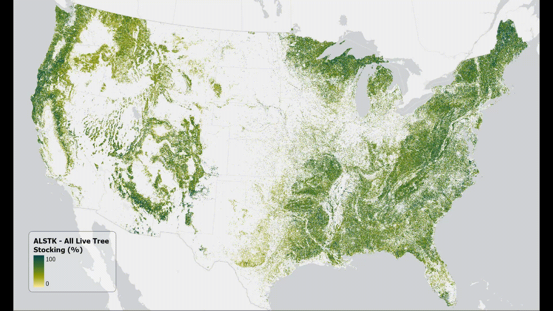
Figure 1. Attribute rasters of TreeMap2016
The data featured here includes 21 data layers available for download at 30m resolution (i.e., each pixel represents a 30x30m ground surface area). These layers are attributes from the main TreeMap dataset that have been separated into their own rasters with values written to the raster band.
These data were collected using funding from the U.S. Government and can be used without additional permissions or fees. If you use these data in a publication, presentation, or other research product please use the appropriate citation:
Year
Citation
2022
Houtman, Rachel M.; Leatherman, Lila S. T.; Zimmer, Scott N.; Housman, Ian W.; Shrestha, Abhinav; Shaw, John D.; Riley, Karin L. 2025. TreeMap 2022 CONUS: A tree-level model of the forests of the conterminous United States circa 2022. Fort Collins, CO: Forest Service Research Data Archive. https://doi.org/10.2737/RDS-2025-0032
2020
Zimmer, Scott N.; Houtman, Rachel M.; Leatherman, Lila S. T.; Housman, Ian W.; Shrestha, Abhinav; Shaw, John D.; Riley, Karin L. 2025. TreeMap 2020 CONUS: A tree-level model of the forests of the conterminous United States circa 2020. Fort Collins, CO: Forest Service Research Data Archive. https://doi.org/10.2737/RDS-2025-0031
2016
Riley, Karin L.; Grenfell, Isaac C.; Finney, Mark A.; Shaw, John D. 2021. TreeMap 2016: A tree-level model of the forests of the conterminous United States circa 2016. Fort Collins, CO: Forest Service Research Data Archive. https://doi.org/10.2737/RDS-2021-0074
Data Products:
These data layers are a set of commonly used plot-level descriptors that have been separated from the main TreeMap dataset's attribute table. Most of these are derived from tree-level data, either as part of the FIA data compilation process or using modifications of standard FIA queries on the published tables to generate plot-level instead of population-level data. In some cases, the variables are recorded directly by crews in the field.
The attributes available for download are:
The sum of stocking percent values of all live trees on the condition.
See Section 2.5.52 of the FIADB User Guide for more information.
Carbon, standing dead (tons per acre). Calculated via the following FIA query:
Query; Sum (DRYBIO_BOLE, DRYBIO_TOP, DRYBIO_STUMP, DRYBIO_SAPLING, DRYBIO_WDLD_SPP) / 2 /2000*TPA_UNADJ WHERE (((COND.COND_STATUS_CD)=1) AND ((TREE.STATUSCD)=2) AND ((TREE.DIA)>=5) AND ((TREE.STANDING_DEAD_CD)=1))
Carbon (tons per acre) of woody material greater than 3 inches in diameter on the ground, and stumps and their roots greater than 3 inches in diameter. Estimated from models based on geographic area, forest type, and live tree carbon density (Smith and Heath 2008).
See Section 2.5.66 of the FIADB User Guide for more information.
Carbon, live above ground (tons per acre). Calculated via the following FIA query:
Query; Sum (DRYBIO_BOLE, DRYBIO_TOP, DRYBIO_STUMP, DRYBIO_SAPLING, DRYBIO_WDLD_SPP) / 2 /2000*TPA_UNADJ WHERE (((COND.COND_STATUS_CD)=1) AND ((TREE.STATUSCD)=1))
Dry standing dead tree biomass, above ground (tons per acre). Calculated via the following FIA query:
Query; Sum (DRYBIO_BOLE, DRYBIO_TOP, DRYBIO_STUMP, DRYBIO_SAPLING, DRYBIO_WDLD_SPP) /2000*TPA_UNADJ WHERE (((COND.COND_STATUS_CD)=1) AND ((TREE.STATUSCD)=2) AND ((TREE.DIA)>=5) AND ((TREE.STANDING_DEAD_CD)=1))
Dry live tree biomass, above ground (tons per acre). Calculated via the following FIA query:
Query; Sum (DRYBIO_BOLE, DRYBIO_TOP, DRYBIO_STUMP, DRYBIO_SAPLING, DRYBIO_WDLD_SPP) /2000*TPA_UNADJ WHERE (((COND.COND_STATUS_CD)=1) AND ((TREE.STATUSCD)=1))
Field-assigned classification of the predominant (based on stocking) diameter class of live trees within the condition.
Code
Description
0
Nonstocked - Meeting the definition of accessible land and one of the following applies (1) less than 10 percent stocked by trees, seedlings, and saplings and not classified as cover trees, or (2) for several woodland species where stocking standards are not available, less than 10 percent canopy cover of trees, seedlings, and saplings.
1
≤4.9 inches (seedlings/saplings). At least 10 percent stocking (or 10 percent canopy cover if stocking standards are not available) in trees, seedlings, and saplings, and at least 2/3 of the canopy cover is in trees less than 5.0 inches d.b.h./d.r.c.
2
5.0-8.9 inches (softwoods)/ 5.0-10.9 inches (hardwoods). At least 10 percent stocking (or 10 percent canopy cover if stocking standards are not available) in trees, seedlings, and saplings; and at least one-third of the canopy cover is in trees greater than 5.0 inches d.b.h./d.r.c. and the plurality of the canopy cover is in softwoods 5.0-8.9 inches diameter and/or hardwoods 5.0-10.9 inches d.b.h., and/or woodland trees 5.0-8.9 inches d.r.c.
3
9.0-19.9 inches (softwoods)/ 11.0-19.9 inches (hardwoods). At least 10 percent stocking (or 10 percent canopy cover if stocking standards are not available) in trees, seedlings, and sapling; and at least one-third of the canopy cover is in trees greater than 5.0 inches d.b.h./d.r.c. and the plurality of the canopy cover is in softwoods 9.0-19.9 inches diameter and/or hardwoods between 11.0-19.9 inches d.b.h., and/or woodland trees 9.0-19.9 inches d.r.c.
4
20.0-39.9 inches. At least 10 percent stocking (or 10 percent canopy cover if stocking standards are not available) in trees, seedlings, and saplings; and at least one-third of the canopy cover is in trees greater than 5.0 inches d.b.h./d.r.c. and the plurality of the canopy cover is in trees 20.0-39.9 inches d.b.h.
5
40.0+ inches. At least 10 percent stocking (or 10 percent canopy cover if stocking standards are not available) in trees, seedlings, and saplings; and at least one-third of the canopy cover is in trees greater than 5.0 inches d.b.h./d.r.c. and the plurality of the canopy cover is in trees greater than or equal to 40.0 inches d.b.h.
See Section 2.5.20 of the FIADB User Guide for more information.
A code indicating the forest type, assigned by the field crew, based on the tree species or species groups forming a plurality of all live stocking. The field crew assesses the forest type based on the acre of forest land around the plot, in addition to the species sampled on the condition.
See Section 2.5.16 and Appendix D of the FIADB User Guide for more information.
This is the forest type used for reporting purposes. It is primarily derived using a computer algorithm, except when less than 25 percent of the plot samples a particular forest condition or in a few other cases.
See Section 2.5.15 and Appendix D of the FIADB User Guide for more information.
The quadratic mean diameter, or the diameter of the tree of average basal area, on the condition. Based on live trees =1.0 inch d.b.h./d.r.c. Calculated via the following FIA query:
Query; SQRT ((COND.BALIVE/?(TREE.TPA_UNADJ))/0.005454), where TREE.STATUSCD=1
Stand density index maximum, Rocky Mountain Research Station. The quadratic mean diameter, or the diameter of the tree of average basal area, on the condition. Based on live trees greater than or equal to 1.0 inch d.b.h./d.r.c.
See Section 2.5.134 of the FIADB User Guide for more information.
Stand density index percent, Rocky Mountain Research Station. A relative measure of stand density for live trees (greater than or equal to 1.0 inch d.b.h./d.r.c.) on the condition, expressed as a percentage of the maximum stand density index (SDI).
See Section 2.5.137 of the FIADB User Guide for more information.
Stand density index (SDI). A relative measure of stand density for live trees (greater than or equal to 1.0 inch d.b.h./d.r.c.) on the condition. Calculated via the following FIA query:
Query; SDIsum = ?(TREE.TPA_UNADJi * (TREE.DIAi/10)1.605), where TPA_UNADJi is the number of trees per acre represented by the ith tree on the plot and DIA is the diameter of the ith tree on the plot and TREE.STATUSCD=1
A classification of the predominant (based on stocking) diameter class of live trees within the condition assigned using an algorithm.
Code
Description
1
Large diameter - Stands with an all live stocking value of at least 10 (base 100); with more than 50 percent of the stocking in medium and large diameter trees; and with the stocking of large diameter trees equal to or greater than the stocking of medium diameter trees.
2
Medium diameter - Stands with an all live stocking value of at least 10 (base 100); with more than 50 percent of the stocking in medium and large diameter trees; and with the stocking of large diameter trees less than the stocking of medium diameter trees.
3
Small diameter - Stands with an all live stocking value of at least 10 (base 100) on which at least 50 percent of the stocking is in small diameter trees.
5
Nonstocked - Forest land with all live stocking value less than 10.
See Section 2.5.19 of the FIADB User Guide for more information.
A unique identifier for each forest plot. Native to TreeMap. Each TM_ID corresponds to a unique plot identifier (CN) in the FIADB. The TM_ID is matched with the CN in the raster attribute table stored in the Forest Service Research Data Archive (2020,2022).
These data have been assembled in one place to provide comprehensive access to the public and researchers alike.
2020 and 2022 data
The following describes the 2020 and 2022 files packaged in each data download. {year}, {study_area} and {attribute} are placeholders for the year, study area and attribute of TreeMap downloaded:
TreeMap{year}_{study_area}_{attribute}.tif - The raster dataset. Values from the corresponding attribute of the main TreeMap{year} dataset have been written to this raster's pixel values.
TreeMap{year}_{study_area}_{attribute}.html - The raster dataset's html metadata, viewable via a web browser.
TreeMap{year}_{study_area}_{attribute}.xml - The raster dataset's xml metadata, viewable via a web browser.
TreeMap{year}_{study_area}_{attribute}.tif.xml - The raster dataset's ArcGIS compatible metadata, viewable in ArcGIS Pro.
TreeMap{year}_{study_area}_{attribute}.tif.aux.xml - The raster dataset's ArcGIS compatible statistics, used by ArcGIS Pro for visualization and analysis. Also used to store attribute tables when applicable.
readme.txt - A readme file describing each file included in the data download as well as instructions for applying the 'official' TreeMap symbology.
TreeMap{year}_{study_area}_{attribute}.tif.lyrx - An ArcGIS layer file containing the official symbology for the attribute. Please see the readme.txt for instructions on how to apply. NOTE: This file is only included for continuous data attributes.
TreeMap{year}_{study_area}_{attribute}.tif.qml - A QGIS layer file containing the official symbology for the attribute. Please see the readme.txt for instructions on how to apply. NOTE: This file is only included for continuous data attributes.
2016 data
The following describes the 2016 files packaged in each data download. {year} and {attribute} are placeholders for the year and attribute of TreeMap downloaded:
TreeMap{year}_{attribute}.tif - The raster dataset. Values from the corresponding attribute of the main TreeMap{year} dataset have been written to this raster's pixel values.
TreeMap{year}_{attribute}.html - The raster dataset's html metadata, viewable via a web browser.
TreeMap{year}_{attribute}.xml - The raster dataset's xml metadata, viewable via a web browser.
TreeMap{year}_{attribute}.tif.xml - The raster dataset's ArcGIS compatible metadata, viewable in ArcGIS Pro.
TreeMap{year}_{attribute}.tif.aux.xml - The raster dataset's ArcGIS compatible statistics, used by ArcGIS Pro for visualization and analysis. Also used to store attribute tables when applicable.
readme.txt - A readme file describing each file included in the data download as well as instructions for applying the 'official' TreeMap symbology.
TreeMap{year}_{attribute}.tif.lyrx - An ArcGIS layer file containing the official symbology for the attribute. Please see the readme.txt for instructions on how to apply. NOTE: This file is only included for continuous data attributes.
TreeMap{year}_{attribute}.tif.qml - A QGIS layer file containing the official symbology for the attribute. Please see the readme.txt for instructions on how to apply. NOTE: This file is only included for continuous data attributes.
A description of each attribute can be found in the 'Data Products' section of this webpage.
Houtman, Rachel M.; Leatherman, Lila S. T.; Zimmer, Scott N.; Housman, Ian W.; Shrestha, Abhinav; Shaw, John D.; Riley, Karin L. 2025. TreeMap 2022 CONUS: A tree-level model of the forests of the conterminous United States circa 2022. Fort Collins, CO: Forest Service Research Data Archive. https://doi.org/10.2737/RDS-2025-0032.
Zimmer, Scott N.; Houtman, Rachel M.; Leatherman, Lila S. T.; Housman, Ian W.; Shrestha, Abhinav; Shaw, John D.; Riley, Karin L. 2025. TreeMap 2020 CONUS: A tree-level model of the forests of the conterminous United States circa 2020. Fort Collins, CO: Forest Service Research Data Archive. https://doi.org/10.2737/RDS-2025-0031
Riley, Karin L.; Grenfell, Isaac C.; Finney, Mark A.; Shaw, John D. 2021. TreeMap 2016: A tree-level model of the forests of the conterminous United States circa 2016. Fort Collins, CO: Forest Service Research Data Archive. https://doi.org/10.2737/RDS-2021-0074