Infrastructure Notice: The Forest Service is undergoing significant infrastructure upgrades that will occur from late this week (starting July 24th) into the beginning of next week. Expect periodic outages during this time. Thank you for your patience as we continue to navigate toward new infrastructure!
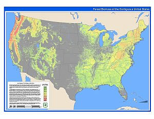
Forest Biomass across the Lower 48 States and Alaska
This geospatial dataset represents the first attempt by the FIA Remote Sensing Band (RSB) to address the need for a geospatial data showing the extent and distribution of forest biomass in greater detail than is possible with the FIA plot data alone. This map was created by modeling forest biomass collected on FIA sample plots as functions of more than sixty geospatially continuous predictor layers. Nearly one-half million FIA sample plots nationwide were used to develop these models. RSB scientists from each FIA unit were responsible for the development of the FIA plot data for their unit. The geospatial predictors were produced at the Forest Service Geospatial Technology and Applications Center (GTAC) with a moderate resolution (250 meters) that is appropriate for the scales of analyses that FIA plot-based estimates support. Among the predictor layers used were digital elevation models (DEM) and DEM derivatives; Moderate Resolution Spectroradiometer (MODIS) multi-date composites, vegetation indices and vegetation continuous fields; class summaries from the 1992 National Land Cover Dataset (NLCD); various ecologic zones; and summarized PRISM climate data.
Modeling was performed using a data mining package, Cubist / See5, which was loosely coupled with Leica Geosystems Imagine image processing software. One significant advantage of Cubist / See5 is that it is a non-parametric modeler that assumes nothing about the structure of the input datasets. Cubist / See5 have also been used successfully in other geospatial modeling programs, such as the revised NLCD. RSB scientists produced the models and biomass geospatial datasets for their FIA unit’s region of responsibility. In addition, each unit produced a forest / non-forest mask. The regional biomass datasets were compiled at GTAC, where the final dataset was produced.
In this map, the map frames of the contiguous United States, Alaska, Hawaii and Puerto Rico are all shown at the same scale. The purpose of this map is to portray the extent and distribution of forest biomass across the United States (note: no biomass data is available for Hawaii). Care should be taken when using all moderate resolution data in geospatial analyses. This data should only be used with data of similar scale and resolution.
Image Files
Image file downloads are zipped together with metadata. Metadata files can also be downloaded separately.
 This geospatial dataset represents the first attempt by the FIA Remote Sensing Band (RSB) to address the need for a geospatial data showing the extent and distribution of forest biomass in greater detail than is possible with the FIA plot data alone. This map was created by modeling forest biomass collected on FIA sample plots as functions of more than sixty geospatially continuous predictor layers. Nearly one-half million FIA sample plots nationwide were used to develop these models. RSB scientists from each FIA unit were responsible for the development of the FIA plot data for their unit. The geospatial predictors were produced at the Forest Service Geospatial Technology and Applications Center (GTAC) with a moderate resolution (250 meters) that is appropriate for the scales of analyses that FIA plot-based estimates support. Among the predictor layers used were digital elevation models (DEM) and DEM derivatives; Moderate Resolution Spectroradiometer (MODIS) multi-date composites, vegetation indices and vegetation continuous fields; class summaries from the 1992 National Land Cover Dataset (NLCD); various ecologic zones; and summarized PRISM climate data.