Reducing the risk of large, high intensity fire (and other mega-disturbances) through forest treatments has become a management imperative in California. The Forest Service has developed/collaborated on multiple initiatives nationally and in partnership with the State of California to accelerate forest restoration efforts in California. A Strategy for Shared Stewardship (2018) and the Wildfire Crisis Implementation Plan (2022) reinforce specific goals for pace and scale of strategic forest treatments over the next decade. Concurrently, the State of California has issued a new Wildfire and Forest Resilience Action Plan (2022), designed to strategically accelerate efforts to restore the health and resilience of California forests through a joint State-Forest Service framework to improve and enhance forest stewardship in California. The social incentives and the scientific knowledge to pursue meaningful restoration of forested landscapes in California are firmly established.
The Pacific Southwest Research Station (PSW) and Region 5 (Mapping and Remote Sensing (MARS) Team) have collaborated to build a comprehensive geospatial dataset for the Sierra Nevada ecoregion. The 68 data themes included capture current landscape conditions representing 10 long-term, landscape-scale outcomes for retaining or restoring resilience. The framework of data provides a structure for assessing landscape conditions, setting objectives, designing projects, and measuring progress towards social-ecological resilience. Data are captured at either 30-meter or 300-meter resolution and all data provided reflect conditions through the 2021 fire season. Those data generated through F3 (i.e. most of the vegetation related data) reflect 2019 conditions (based on FIA plot data), but were also updated through the 2021 season using remotely sensed data. Access to high-resolution remote sensing and GIS data sources, experiences with landscape restoration assessment and modeling efforts, and advancements in high-performance computing capabilities now enable the Region and Station to take significant steps to plan and work effectively at a landscape scale.
Data Availability:
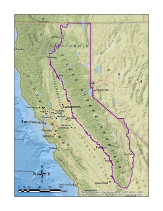
Figure 1. ACCEL Boundary for data in the Sierra Nevada
All 68 data themes are now available for download. Data were initially released primarily at 300 m resolution (i.e. pixels are 300 meter on a side) and became available at 30 m resolution in February 2023. The same data layers at both spatial resolutions are also available rescaled to a value of -1 to +1 to put all data layers in the same units for additional analytical work among metrics and pillars.
Data layers are available for viewing via a read-only map service hosted on an ArcGIS server and can be viewed with applications such as ArcGIS Online Map Viewer (AGOL), ArcMap, ArcGIS Pro and kml for Google Earth. Layers are grouped in the map by Pillars and allow for panning, zooming and transparency with options for visualization over many types of basemaps.
Data Access:
Use Constraints: These data were collected from multiple sources, some which have specified use constraints. All data developed by the U.S. Government can be used without additional permissions or fees. Data developed by other sources may have other constraints. Please check each metric and their source to determine if any additional disclaimers exist. A full list of disclaimers by organization is available at the end of this webpage.
Appropriate use includes regional to assessments of vegetation cover, land cover, or land use change trends, total extent of vegetation cover, land cover, or land use change, and aggregated summaries of vegetation cover, land cover, or land use change. Further use includes applying these data to assess management opportunities for treatments to restore landscape resiliency.
There are use disclaimers and restrictions for specific data layers. Please review the information below under "Data Credit and Disclaimers" and consult any specifics for each metric when downloading data.
Data Products:
The metrics are organized by the 10 pillars of resilience in the Framework for Resilience. Each pillar represents a resource outcome associated with resilient forest landscapes. There are 66 metrics within the resource kit that span the 10 pillars. The Metrics describe the characteristics of the elements (key characteristics) of each pillar in quantitative or, in a few cases, qualitative terms. Metrics are used to assess, plan for, measure, and monitor progress toward desired outcomes and greater resilience. Metrics are selected to be informative, meaningful, and actionable to meet the needs of management.
The metrics included are:
Air Quality
CLEAN AIR IS IMPORTANT to human health and wellness, clean water, biodiversity, and ecosystems. Catastrophic wildfires degrade air quality and cause respiratory illnesses that affect millions of people, especially children and people who work outdoors. Furthermore, people prefer to enjoy the outdoors when it is safe to breathe, and the skies are clear. Smoke from wildfires discourages recreation and disrupts businesses and local economies. Land managers seek to improve forest health and resilience by using prescribed fire to reduce the risk of uncharacteristic fire and smoke.
OUTCOME: Emissions from fires are limited to primarily low- and moderate-severity fires in wildland ecosystems. Forests improve air quality by capturing pollutants.
Forest Service - Pacific Southwest Research Station (PSW); Forest Service - Region 5 Mapping and Remote Sensing (MARS) Team; Forest Service - Region 6, Pacific Northwest Research Station (PNW) - Forest Inventory And Analysis (FIA) Program
Biodiversity Conservation
BIODIVERSITY PLAYS A MAJOR ROLE in our ecosystems and society. Native plants and animals help forests recover after a fire, control flooding and soil erosion, and cycle nutrients. Biodiversity also holds cultural value, including Native American uses, and provides recreational benefits like birdwatching. Greater species diversity promotes adaptability and helps ecosystems withstand and recover from disturbances, including those caused by a changing climate.
OUTCOME: The network of native species and ecological communities is sufficiently abundant and distributed across the landscape to support and sustain their full suite of ecological and cultural roles.
Forest Service - Pacific Southwest Research Station (PSW); Forest Service - Region 5 Mapping and Remote Sensing (MARS) Team; US Geological Survey - Earth Resources Observation and Science (EROS) Center; Forest Service - Region 5 and Pacific Southwest Research Station (PSW); California Department of Fish and Wildlife; UC Davis; California Forest Observatory - Salo Sciences
Carbon Sequestration
CARBON SEQUESTRATION IS THE PROCESS by which carbon dioxide is taken up by trees, grasses, and other plants and stored as carbon in biomass and soils. Resilient forests and wetlands can be net sinks of carbon and can play an important role in reducing greenhouse gas emissions into the atmosphere, thereby mitigating climate change. Forest products also play a role in storing carbon for decades in building materials, thereby delaying emissions.
OUTCOME: Carbon sequestration is enhanced in a stable and sustainable manner that yields multiple ecological and social benefits.
UC Irvine; Forest Service - Pacific Southwest Research Station (PSW); Forest Service - Region 5 Mapping and Remote Sensing (MARS) Team; Forest Service - Region 6, Pacific Northwest Research Station (PNW) - Forest Inventory And Analysis (FIA) Program
Economic Diversity
ECONOMIC DIVERSITY INCREASES business opportunities that provide regional economic vitality and additional benefits to rural and vulnerable populations. Resilient forests provide ecosystem services and forest products that in turn provide a foundation for many local and regional economic activities and employment opportunities, including recreation, tourism, and natural resource management industries.
OUTCOME: Forest management and outdoor activities support a sustainable, natural-resource-based economy, particularly in rural communities.
Forest Service - Pacific Southwest Research Station (PSW); Forest Service - Region 5 Mapping and Remote Sensing (MARS) Team; Forest Service - Region 6, Pacific Northwest Research Station (PNW) - Forest Inventory And Analysis (FIA) Program; Forest Service - Rocky Mountain Research Station (RMRS)
Fire Adapted Communities
DUE TO CLIMATE CHANGE and other drivers, wildfires increasingly threaten homes and communities, especially in the wildland-urban interface. Fire adapted communities are knowledgeable and engaged. They accept fire as part of the surrounding landscape, take action to reduce their vulnerability to fire, and adapt to live safely with fire.
OUTCOME: Communities have adapted to live safely in forested landscapes and understand the significance of fire to maintaining healthy forests. They have sufficient capacity to manage desired fire and suppress unwanted fire.
Pyrologix, LLC; US Geological Survey Geosciences and Environmental Change Science Center
Fire Dynamics
FIRE IS AN INTEGRAL PART of Sierra Nevada forest ecosystems, which are evolutionarily adapted to fire. Ideally prescribed fires and managed wildfires would be allowed to burn across the landscape periodically. They would burn primarily at low to moderate severity in a mosaic pattern that covers large areas, which would provide substantial ecological benefits. Because climate change generally increases the severity of fire dynamics, managing such dynamics will continue to grow in importance.
OUTCOME: Fire burns in an ecologically beneficial and socially acceptable way that perpetuates landscape heterogeneity and rarely threatens human safety or infrastructure.
CALFIRE; Pyrologix, LLC; Forest Service - Pacific Southwest Research Station (PSW); Forest Service - Region 5 Mapping and Remote Sensing (MARS) Team; Forest Service - Region 6, Pacific Northwest Research Station (PNW) - Forest Inventory And Analysis (FIA) Program
Forest Resilience
RESILIENT FORESTS PROVIDE many ecosystem services, including wildlife habitat, clean water, stable soils, recreational opportunities, biodiversity, wood products, and carbon sequestration. They also play an important role in both mitigating and adapting to climate change. Across the landscape, management activities and natural disturbances should maintain desired forest conditions, including forest heterogeneity and wildlife habitat.
OUTCOME: Vegetation composition and structure align with topography, desired disturbance dynamics, and landscape conditions, and are adapted to climate change.
UC Davis; Forest Service - Pacific Southwest Research Station (PSW); Forest Service - Region 5 Mapping and Remote Sensing (MARS) Team; Forest Service - Region 6, Pacific Northwest Research Station (PNW) - Forest Inventory And Analysis (FIA) Program; California Forest Observatory - Salo Sciences; UC Irvine; School of Environmental and Forest Sciences, University of Washington;
Social and Cultural Well-Being
A GROWING BODY OF EVIDENCE indicates that greater exposure to nature is associated with better health and well-being. Sierra Nevada forests allow people to build and maintain active cultural and social connections to a place. Resilient landscapes offer opportunities for people to connect with the natural environment through recreation experiences, culturally valued resources, and engagement in natural resource management and conservation.
OUTCOME: The landscape provides a place for people to connect with nature, to recreate, to maintain and improve their overall health, and to contribute to environmental stewardship, and is a critical component of their identity.
Forest Service - Washington Office (WO); Office of Environmental Health Hazard Assessment, CAL EPA
Water Security
RESILIENT FORESTED WATERSHEDS are key for regional and statewide water security. The economic value of California's water far exceeds that of any other forest product. Water flows from forests into rivers that provide critical aquatic and wetland habitat, and that supply agricultural and drinking water for tens of millions of people. Forests serve as natural water collection, storage, filtration, and delivery systems. These functions will become more important as climate change intensifies.
OUTCOME: Watersheds provide a reliable supply of clean water despite wide swings in annual precipitation, droughts, flooding, and wildfire.
WETLANDS PROVIDE critical habitat, filter and retain nutrient pollution, store carbon, enhance water quality, control erosion, and provide spaces for recreation. They are local and regional centers of biodiversity, and support species found nowhere else across western landscapes. Functional wetland ecosystems will serve increasingly important roles in buffering impacts from extreme climate events, and upland disturbances such as flooding and erosion.
OUTCOME: Meadow and riparian ecosystems provide multiple ecosystem services and are key linkages between upland and aquatic systems in forested landscapes.
Land designations - wilderness, roadless, wild and scenic river
Ownership
Roads
Building structure density
High use recreation areas
Data Dictionary:
These data have been assembled in one place to provide comprehensive access for land managers. Accompanying all the data is a metric dictionary which provides details on the nature of each metric. Each metric has been defined to help end-users of the data (and for use with any decision support tools) to understand:
The definition meant by a given metric
The expected use(s) of the metric
The resolution of the developed data
The data sources used to derive the metric
The method of metric derivation
The root file names
Where appropriate, we have included a measure that reflects more favorable conditions, in terms of resilience to disturbance.
References have been included to help the reader understand potential methods for deriving metrics. It is our hope this information will help people make better use of all the assembled information and how it can best be used with various decision support tools. This dictionary will be updated periodically, as necessary.
Forest Service Use Constraints - The Forest Service makes no warranty, expressed or implied, including the warranties of merchantability and fitness for a particular purpose, nor assumes any legal liability or responsibility for the accuracy, reliability, completeness, or utility of these geospatial data, or for the improper or incorrect use of these geospatial data. These geospatial data and related maps or graphics are not legal documents and are not intended to be used as such. The data and maps may not be used to determine title, ownership, legal descriptions or boundaries, legal jurisdiction, or restrictions that may be in place on either public or private land. Natural hazards may or may not be depicted on the data and maps, and users should exercise due caution. The data are dynamic and may change over time. The user is responsible to verify the limitations of the geospatial data and to use the data accordingly.
Forest Service Distribution Liability - The Forest Service manages resource information and derived data as a service to users of Forest Service digital geographic data. The Forest Service is in no way condoning or endorsing the application of these data for any given purpose. It is the sole responsibility of the user to determine whether or not the data are suitable for the intended purpose. It is also the obligation of the user to apply those data in an appropriate and conscientious manner. The Forest Service provides no warranty, nor accepts any liability occurring from any incorrect, incomplete, or misleading data, or from any incorrect, incomplete, or misleading use of these data.
Forest Service - Pacific Southwest Research Station (PSW)
Forest Service - Region 5 Mapping and Remote Sensing (MARS) Team - use of F3 or derived products should include the following citation (in addition to Burrill et al. 2018): Huang, S.; Ramirez, C.; McElhaney, M.; Evans, K. 2018. F3: Simulating spatiotemporal forest change from field inventory, remote sensing, growth modeling, and management actions. Forest Ecology and Management 415-416: 26-37.
Forest Service Rocky Mountain Research Station (RMRS)
Forest Service, Pacific Northwest Research Station, Forest Inventory and Analysis Program - use of F3 or derived products should include the following FIA citation (in addition to Huang et al. 2018): Burrill, Elizabeth A.; Wilson, Andrea M.; Turner, Jeffery A.; Pugh, Scott A.; Menlove, James; Christensen, Glenn; Conkling, Barbara L.; David, Winnie. 2018. The Forest Inventory and Analysis Database: database description and user guide version 8.0 for Phase 2. U.S. Department of Agriculture, Forest Service. 946 p. [Online]. Available at web address: Burrill et al. 2018.
U.S. Geological Survey (USGS) - Unless otherwise stated, all data, metadata and related materials are considered to satisfy the quality standards relative to the purpose for which the data were collected. Although these data and associated metadata have been reviewed for accuracy and completeness and approved for release by the U.S. Geological Survey (USGS), no warranty expressed or implied is made regarding the display or utility of the data for other purposes, nor on all computer systems, nor shall the act of distribution constitute any such warranty.
Pyrologix - Primary data contact: James Newman (California State BLM Office) jnewman@blm.gov This 2022 dataset is an update produced by Pyrologix for the Bureau of Land Management (BLM) California State Office. The original 2020 dataset was developed by Pyrologix for the Forest Service Pacific Southwest Region. Citation for this data is in the References section below.
UC Irvine - The University of California ("UC") makes the materials on this website available pursuant to the following disclaimers: the materials are offered "as is"; user assumes any and all risks, of any kind or amount, of using these materials; user shall use the materials only in accordance with law; user releases, waives, discharges and promises not to sue UC, its directors, officers, employees or agents, from liability from any and all claims, including the negligence of UC, resulting in personal injury (including death), accidents or illnesses, property loss, as well as any and all loss of business and/or profit in connection with user's use of the materials; and user shall indemnify and hold UC harmless from any and all claims, actions, suits, procedures, costs, expenses, damages, and liabilities, including attorney's fees, arising out of user's use of the materials and shall reimburse UC for any such incurred expenses, fees or costs.
The CECS data layers may be used under comparable terms. The specific data use license is a Creative Commons BY-SA agreement.
California Department of Fish and Wildlife - Terrestrial Connectivity, Areas of Conservation Emphasis (ACE), version 3.1. Last updated 08/21/2019.The Terrestrial Connectivity dataset is one of the four key components of the California Department of Fish and Wildlife's (CDFW) Areas of Conservation Emphasis (ACE) suite of terrestrial conservation information.
UC Davis - The University of California ("UC") makes the materials on this website available pursuant to the following disclaimers: the materials are offered "as is"; user assumes any and all risks, of any kind or amount, of using these materials; user shall use the materials only in accordance with law; user releases, waives, discharges and promises not to sue UC, its directors, officers, employees or agents, from liability from any and all claims, including the negligence of UC, resulting in personal injury (including death), accidents or illnesses, property loss, as well as any and all loss of business and/or profit in connection with user's use of the materials; and user shall indemnify and hold UC harmless from any and all claims, actions, suits, procedures, costs, expenses, damages, and liabilities, including attorney's fees, arising out of user's use of the materials and shall reimburse UC for any such incurred expenses, fees or costs.
Office of Environmental Health Hazard Assessment, CAL EPA - The CalEnviroScreen 4.0 model is based on CalEPA's definition of cumulative impacts. The model is based on geography, specifically census tracts in California. It presents information for the entire state.
California Natural Resources Agency, CALFIRE - The State of California and the Department of Forestry and Fire Protection make no representations or warranties regarding the accuracy of data or maps. The user will not seek to hold the State or the Department liable under any circumstances for any damages with respect to any claim by the user or any third party on account of or arising from the use of data or maps. The user will cite the Department of Forestry and Fire Protection as the original source of the data, but will clearly denote cases where the original data have been updated, modified, or in any way altered from the original condition.
U.S. Fish and Wildlife Service - The use of trade, product, industry or firm names is for informative purposes only and does not constitute an endorsement by the U.S. Government or the Fish and Wildlife Service. Links to non-Service Web sites do not imply any official U.S. Fish and Wildlife Service endorsement of the opinions or ideas expressed therein or guarantee the validity of the information provided. Base cartographic information used as part of the Wetlands Mapper has been provided through a license agreement with ESRI and the Department of the Interior.
Salo Sciences Inc. - California Forest Observatory is a forest monitoring platform that maps vegetation fuels and wildfire hazard across the state, operated by Salo Sciences, Inc. Terms of use are detailed at California Forest Observatory Legal Terms.
For all data layers you are free to share, copy, and re redistribute the material in any medium or format AND adapt, remix, transform, and build upon the material for any purpose, even commercially under the following terms:
Attribution - You must give appropriate credit, provide a link to the license, and indicate if changes were made. You may do so in any reasonable manner, but not in any way that suggests the licensor endorses you or your use.
ShareAlike - If you remix, transform, or build upon the material, you must distribute your contributions under the same license as the original.
No additional restrictions - You may not apply legal terms or technological measures that legally restrict others from doing anything this license permits.