Infrastructure Notice: The Forest Service is undergoing significant infrastructure upgrades that will occur from late this week (starting July 24th) into the beginning of next week. Expect periodic outages during this time. Thank you for your patience as we continue to navigate toward new infrastructure!
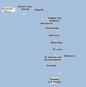
Land Cover and Forest Formations for: Puerto Rico, the Virgin Islands, St. Kitts and Nevis, St. Eustatius, Grenada, Barbados, Trinidad and Tobago.
The International Institute of Tropical Forestry and partners have mapped forest types and land cover in the Caribbean since 2002 to support forest management. Raster data and maps from this work are are downloadable here and described in the studies listed. The United Nations Food and Agriculture Organization used these data in their global forestry assessments for 2005 and 2010, and the Puerto Rico data are the basis for recent National data (NLCD 2000).
We found that over much of the Caribbean forest cover is increasing, and we expect it will continue to rise. In the Lesser Antilles, where little was known about these trends, cultivated land areas declined 60 to 100 percent from 1945 to 2000, while forest cover increased by 50 to 950%. This trend will likely continue, because growing sugar cane for sugar is no longer profitable on Caribbean islands. Trinidad and Tobago, and St. Kitts and Nevis, for example, have both stopped subsidizing sugar production. Besides extensive abandoned cane fields in Trinidad and Tobago, we found extensive areas of abandoned woody agriculture that is now forest.
For Trinidad and Tobago, we mapped tropical forests with more detail than for the other islands, mapping tree communities within more general forest types. For example, instead of only mapping seasonal evergreen forest as one class, we mapped several different tree communities that fall within the category of seasonal evergreen forest. We discovered that satellite imagery from severe drought was most useful for distinguishing among these communities.
Studies that describe the work and land-cover trends: