Risk assessment is practice for analyzing the potential frequency, intensity, and consequences of an uncertain process like wildfire. The typical Quantitative Wildfire Risk Assessment (QWRA) produced to inform wildfire and fuels management planning is intended to characterize broad spatial patterns in potential wildfire frequency and intensity across large landscapes at decade or longer time scales, and how critical resources and assets may be exposed to and respond to wildfire.
Figure 1. The factors that go into determining wildire risk assessment.
Purpose and Forest Service Directives
Risk assessments are intended to improve understanding of risk drivers, magnitude, and spatial patterns across large landscapes to inform wildfire and fuels management planning. The US Forest Service Manual Chapter 5140 directs the National Office Director of Fire and Aviation Management, Regional Foresters, and Forest Supervisors to develop and use risk assessment models to identify and prioritize hazardous fuels reduction projects. These regional QWRAs are intended for regional planning, but they are often suitable for sub-regional or forest planning.
Methods Framework
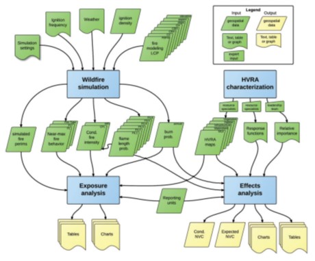
Each Regional QWRA includes a report with detailed methods that is important to read and understand before using the data. All Regional QWRAs follow the general framework described in “A Wildfire Risk Assessment Framework for Land and Resource Management” also known as Rocky Mountain Research Station General Technical Report 315 (Scott et al. 2013). The primary components required to apply the framework spatially include the simulation of wildfire hazard, identification and characterization of highly valued resources and assets, and effects analysis to quantify risk.
Figure 2. The modelling framework.
Wildfire hazard is characterized in terms of fire likelihood (or “burn probability”) and fire intensity estimates from wildfire spread and behavior models. Many wildfire risk assessments use FSim, the large fire simulation system, to generate spatially explicit, probabilistic assessments of wildfire hazard (Finney et al. 2011). FSim is a stochastic modeling system that simulates the growth and behavior of many individual fire events over thousands of fire seasons using geospatial data on historical fire occurrence, weather, terrain, and fuel conditions. Some newer assessments use FSim to estimate fire likelihood and The Wildfire Exposure Simulation Tool (WildEST; Scott et al. in prep) to model potential fire intensity using similar but deterministic methods.
Highly Valued Resources and Assets (HVRAs) are fire-sensitive elements of the natural and built environment that drive land, resource, and fire management decision making. Common examples include human assets, like buildings, critical infrastructure, and developed recreation sites, and natural resources, like municipal watersheds, merchantable timber, and rare wildlife habitat. Resource specialists are the primary points of contact for spatial data access, interpretation, and application, and they help to define the tabular response functions used to relate fire intensity to HVRA response using the Net Value Change (NVC) concept. NVC captures both fire-related losses and benefits in relative terms on a percentage basis (e.g., -100% indicates complete loss and +100% indicates maximum benefit), allowing for a common currency to evaluate wildfire risk across HVRAs. Leadership teams also rank HVRAs in terms of relative importance for weighting their contribution to “integrated” or “total” risk metrics. The intent of relative importance weighting is to capture fire and land management objectives and priorities as well as social values (Scott et al. 2013; Thompson et al. 2013).
Final risk calculations are based on wildfire hazard, HVRA exposure, fire effects, and relative importance. Results are typical presented as conditional NVC (cNVC) and expected NVC (eNVC). “Conditional” means given exposure to fire. “Expected” means accounting for fire likelihood. cNVC should be thought of as a quick reference for evaluating the direction and magnitude of fire effects to inform fire response planning. eNVC should be used for pre-fire mitigation planning, including hazardous fuels reduction, to target mitigation efforts in areas with highly negative eNVC. Risk metrics (cNVC and eNVC) are also calculated at the HVRA level for resource-specific risk assessment and planning.
Data elements for each region:
Report
Total cNVC GeoTIFF
Total eNVC GeoTIFF
HVRA-level cNVC GeoTIFFs (typically 5-7 per region)
HVRA-level eNVC GeoTIFFs (typically 5-7 per region)
Links to associated image services (if available)
Optional layer files with recommended symbology can be bundled with each GeoTIFF download