Infrastructure Notice: The Forest Service is undergoing significant infrastructure upgrades that will occur from late this week (starting July 24th) into the beginning of next week. Expect periodic outages during this time. Thank you for your patience as we continue to navigate toward new infrastructure!
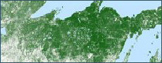
The US Forest Service and Research and Development - Forest Inventory and Analysis builds and maintains Tree Canopy Cover (TCC) datasets for the conterminous U.S. (CONUS), coastal Alaska (SEAK), Puerto Rico and the U.S. Virgin Islands (PRUSVI), and Hawaii. Since the TCC datasets cover all lands including federal, state, and private lands, multiple divisions of the Forest Service contribute funding supporting the development and production of the datasets. These divisions include the National Forest Systems, State and Private Forestry, and Research and Development. The TCC datasets are Landsat and Sentinel-2 based with a spatial resolution of 30 meters.
An annual Science product (direct model outputs, per pixel SE, and model uncertainty) with maps and data for years 1985-2025, that serve multiple user communities.
Additional 2025.6 TCC product suite components and download links are provided below under "Current Data Release".
Additional documentation describing the components of the TCC Product Suite (workflows, inputs, models, QC and review processes, etc.) is available at the bottom of this page.
Science TCC product includes 30-meter spatial resolution maps of TCC and standard error for years 1985-2025.
Two-layer dataset, with modeled TCC values on every pixel, along with a standard error value + metadata
Provides objective numerical model outputs
Masks and thresholds are not applied to the Science version. TCC in water bodies or non-tree croplands (e.g., center-pivot irrigated fields) may be present.
Produced by the Forest Service
Data for the years 1985 through 2023 are available below.
Description:
NLCD TCC product suite includes 30- meter spatial resolution maps of TCC for the years 1985 through 2025.
The NLCD TCC data are the result of more in-depth post-processing of the Science products, including various masking (i.e., water and non-tree agriculture), filtering, minimum-mapping unit (MMU) routines, and a process to reduce interannual noise and return longer duration trends.
Produced by the Forest Service as a partner in the Multi-Resolution Land Characteristics Consortium (MRLC)
Primary User Community:
This version serves a user community that prizes statistics over visual appearance.
This community typically has access to advanced geospatial and statistical analysis resources.
Primary User Community:
This version serves a large part of the NLCD user community that desires:
Maps with reasonable cartographic appearance and reduced interannual noise.
Science TCC product includes 30-meter spatial resolution maps of TCC and standard error for years 1985-2023.
Two-layer dataset, with modeled TCC values on every pixel, along with a standard error value + metadata
Provides objective numerical model outputs
Masks and thresholds are not applied to the Science version. TCC in water bodies or non-tree croplands (e.g., center-pivot irrigated fields) may be present.
Produced by the Forest Service
Data for the years 2008 through 2021 are available below.
Description:
NLCD TCC product suite includes 30- meter spatial resolution maps of TCC for the years 1985 through 2023.
The NLCD TCC data are the result of more in-depth post-processing of the Science products, including various masking (i.e., water and non-tree agriculture), filtering, minimum-mapping unit (MMU) routines, and a process to reduce interannual noise and return longer duration trends.
Produced by the Forest Service as a partner in the Multi-Resolution Land Characteristics Consortium (MRLC)
Primary User Community:
This version serves a user community that prizes statistics over visual appearance.
This community typically has access to advanced geospatial and statistical analysis resources.
Primary User Community:
This version serves a large part of the NLCD user community that desires:
Maps with reasonable cartographic appearance and reduced interannual noise.